Listeners:
Top listeners:
-
 play_arrow
The Breeze Radio The Breeze Radio
Erin Expected To ‘Explode’ Into Category 4 Hurricane: See Potential Long Island Impacts
As the storm intensifies into hurricane status, forecasters warn that high waves and strong rip currents could impact Long Island.
LONG ISLAND, NY — As Tropical Storm Erin intensifies, the National Hurricane Center said the storm is expected to officially become a hurricane on Friday, with potential impacts across Long Island.
“Erin is forecast to explode into a powerful Category 4 hurricane as it moves across very warm waters in the open Atlantic. Water temperatures at the surface and hundreds of feet deep are several degrees higher than the historical average,” said Accuweather’s lead hurricane expert Alex DaSilva said.
Protruding coastal areas, including Long Island, “face a higher risk of direct and potentially severe tropical storm or hurricane conditions than much of the southern Atlantic, mid-Atlantic and northern New England coasts,” AccuWeather.com said.
Joe Pollina, meteorologist with the National Weather Service Office in Upton, told Patch Thursday that the National Hurricane Center was issuing advisories on Tropical Storm Erin, slated to become the first Atlantic hurricane of the season.
Forecasters are warning of dangerous riptides across the Long Island region early next week due to Erin’s wrath, including pounding surf, he said.
“Powerful seas” are expected, AccuWeather.com added.
Experts said it’s too early to forecast impacts of wind, rain, or storm surge to Long Island, but advised beachgoers to keep an eye on the waves as the storm intensifies.
“As Erin moves into the Western Atlantic and strengthens, it’s going to produce a large wave field,” National Hurricane Center Deputy Director Jamie Rhome said Friday, with a chart of the storm’s wave field.
According to Rhome, brighter colors in the chart indicate higher ocean waves, with the potential to reach up to 35 feet.
“As those waves move toward the east coast of the United States, it’s going to produce a big rip current risk later in the weekend, early next week,” Rhome said. “So if you’re going to the beach, you really have to pay attention.”
Regardless of Erin’s exact track, Rhome said the threat of rip currents will still materialize and advised those headed to the beach to swim near a lifeguard and check hazard warnings at their local beach beforehand.
In a Friday morning update from the National Hurricane Center, authorities said the storm has maximum sustained winds of 70 MPH — up from 60 MPH on Thursday — and was moving northwest at 17 MPH from its location several hundred miles east of the northern Leeward Islands.
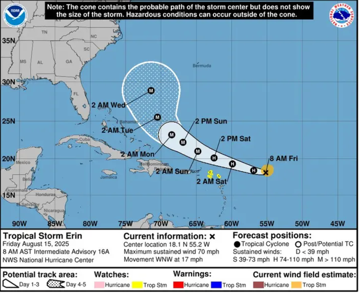
Once the storm leaves the Caribbean, Erin will set its sights on the east coast of the United States, with the severity of its impacts dependent on its track, according to a report from AccuWeather.
“At this time, impacts are expected to include dangerous surf, beach erosion and coastal flooding,” DaSilva said. “However, conditions may worsen along the U.S. Atlantic coast, if Erin’s track shifts farther west.”
As of Friday morning, AccuWeather’s team of meteorologists said they expect the most likely path of Erin to keep the eye of the hurricane east of the United States, though the storm is forecast to grow in strength and size.
As the storm grows, AccuWeather said its field of influence “may become extensive” with tropical storm conditions possibly extending outward from the center by 100 miles or more.
As of Friday morning, DaSilva said Erin has not yet started to curve north, though the longer the storm tracks west before turning north, the odds increase of impacts potentially reaching the East Coast.
“Be vigilant if you’re going to an East Coast beach next week,” DaSilva said. “Be aware of rip current warning signs and only swim in areas with lifeguards on duty.”


-

Nights with Ventura
Ventura Smalley is a nationally syndicated radio host known for his warm voice, heartfelt conversations, and unforgettable love song dedications. With a deep passion for radio that began in his childhood, Ventura got behind the mic at just 14 years old and landed his first major radio gig by the age of 15. Born and raised in California, Ventura has always believed in the power of connection through music. His nightly show brings comfort, advice, and the perfect soundtrack for listeners across the country who are celebrating love, healing from heartbreak, or simply looking for someone who understands. Ventura lives and breathes radio — not just playing the songs, but hearing the stories behind them. Whether he’s talking one-on-one with a caller or sharing a listener’s dedication on-air, he brings sincerity, empathy, and a true passion for helping people feel heard.
close Chart
-
-
 play_arrow
Nobody Knows The Tony Rich Project
-
-
-
 play_arrow
Bring It All to Me (feat. *NSYNC) Blaque
-
-
-
 play_arrow
I Swear All-4-One
-
-
Top popular

Billy Joel’s Oyster Bay Motorcycle Shop To Close This Month

Brood Of 7 Ducklings Saved From Storm Drain On Long Island Expressway

2 Charged In Connection With Unlicensed Cannabis Sales At Smoke Shops In Brookhaven Town: Cops

How the Passage of the ‘Big, Beautiful Bill’ Could Impact Med Students and Hospitals

Erin Expected To ‘Explode’ Into Category 4 Hurricane: See Potential Long Island Impacts


Post comments (0)